
Oirasé Mountain Stream
Deep greenery in Aomori Prefecture
Nestled between two prefectures in Towada-Hachimantai National Park, Lake Towada is the third-deepest lake in Japan. It is drained by the Oirasé River (pronounced oi-rah-say), flowing 67 km (42 miles) through Aomori Prefecture to the Pacific Ocean.
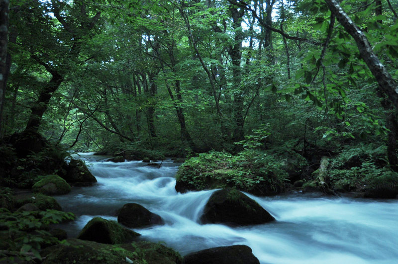
The first 14 km (8.7 miles) of the Oirasé River are referred to as the Oirasé Mountain Stream (Oirasé Keiryuu), a region of steep, dark-stoned cliffs filled with luxuriant ferns and rich mosses. The little Oirasé River courses through tight rapids and rounded boulders, the moisture-rich air lending a soft, cottony touch even to the frothing white waters. To the left and right, narrow waterfalls cascade down the cliff-face to join the river, presided over by deep growths of Japanese beech and oak.
The Oirasé Mountain Stream hiking course weaves around the only road through the area, beginning at the Nenokuchi bus stop on Lake Towada. Though the course technically comes to an end at the Yakeyama bus stop, most hikers only walk the first 9 km (5.6 miles) to Ishigedo.
The murky gloom of late afternoon is a magical time to explore the gorge. Be forewarned, however, that buses are infrequent, and even the taxis stop running at dusk. It’s a good idea to start by getting dropped off, then allow yourself enough time to hike your way back.
Oirasé Mountain Stream is about two hours by bus from Aomori City on the way to Lake Towada. Lake Towada can also be accessed by bus from Morioka in Iwate Prefecture.
Also in the Area

The largest caldera lake on Japan's main island.

Buddha's coast and haunted temples at Honshu's most northern point.
Published October 2009. Photos © 2009 Michael Kanert.