Most. Snow. Ever.
Tateyama’s Yuki-no-Ōtani
The Tateyama-Kurobé Alpine Route is a 37-km (23 mile) course through the Japan Alps that runs from Toyama City to the town of Ōmachi, near Matsumoto. Connecting Toyama Prefecture with Nagano, the course was first opened in 1971, and involves trains, buses, cable-cars, and gondolas spanning nearly 2,000 m (6,562 ft) of vertical differentiation.
The course begins on Mt. Taté, which, along with Mt. Fuji and Mt. Haku (located at the intersection of Gifu, Fukui, and Ishikawa Prefectures), is one of the three holiest mountains in Japan. Key sights on the route include panoramic views of the Japan Alps (particularly renowned in autumn); Kurobé Dam, the largest dam in Japan; and the Tateyama Caldera, the largest caldera on mainland Japan. But for two months in spring, the undisputed top attraction is the great snow field of Yuki-no-Ōtani.
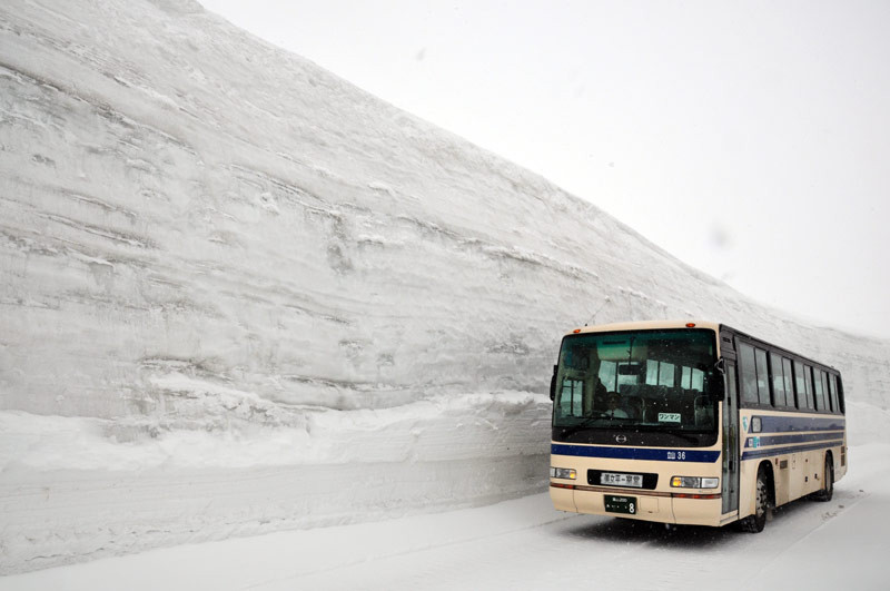
This year open from April 17th to May 31st, Yuki-no-Ōtani is located 2,450 m (8,038 ft) up the side of Mt. Taté’s 3,015-m (9,892 ft) peak, and is reputed to be the snowiest place in Japan. Every spring, a team of bulldozers and snow-blowers follows GPS markers across the mountainside to carve a narrow two-lane road through a snow pack reaching over 20 m (66 ft) in height.
Traveling out of Dentetsu Toyama Station in Toyama City, the journey begins with a clunky hour on the infrequent trains of the Toyama Chiho Railway (¥1170). From Tateyama Station, a cable-car swiftly ascends 502 m (1,647 ft) to Bijodaira Station, where buses await to take visitors 23 km (14 miles) along winding mountain roads to Murodō Terminal. The Yuki-no-Ōtani walking course is only open from 10:00 to 3:15 each day, so the window is always tight.
Electing to visit on the Friday of the Golden Week holiday, my girlfriend and I exited the half-empty train at Tateyama Station to find ourselves in a crush of people worthy of a Friday night in Shibuya. Cable-cars, departing only once every 20 minutes, were booked solid for two hours in advance. We each dropped ¥4190 for a round-trip ticket to Murodō Terminal, then killed time by nosing around the free displays in the Tateyama Caldera Sabo Museum (sabo = erosion control) and visiting Shōmyō-daki, the highest waterfall in Japan.
Finally arriving at Bijodaira Station, we quickly found seats on one of the stream of buses departing for the snow fields. There were already decent snow drifts lining the road by the station, and the snow level rose gradually as the bus passed through an expansive forest of cedar interspersed with birch, pausing once to let us take photos of a 1000-year-old cedar, then again to give us a distant view of Shōmyō-daki. Soon the trees began to fall away as the snow started to rise up, finally enclosing us in a narrow canyon of ice three times as high as the bus.
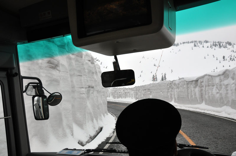
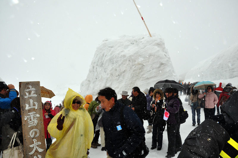
If Tateyama had been Shibuya, then Murodō Terminal must have been Shinjuku, because it was just as ridiculously crowded. We shouldered our way outside to get to the Ōtani Road, a 500-m (547 yd) stretch of the snow corridor that’s open to pedestrians. The corridor reached a maximum height of 15 m (49 ft) this year, but unlike the blue-skied images shown in all the ads, we stepped outside the terminal to meet a snowy hellscape, high winds throwing the white stuff around everywhere and dropping the actual temperature well below the atmospheric -1 C (30 F). The girls in mini-skirts and families with baby strollers had clearly had no idea what they were in for.
A trail called the Panorama Road runs outside the snow corridor, and while it normally offers views of the white-capped Japan Alps, stepping off the main road that day was just an invitation to be lashed by the wind in the midst of a blinding white haze. Walking off-course is prohibited, but the buses specifically listed a ¥300 surcharge for skis and snowboards. It seems that once in a while a hot-dogger will try to jump the snow corridor, though they don’t always make it.
While some people went to the end of the Ōtani Road, we’d made the decision to go as far as the first turn and then head back. It was already 3:00 in the afternoon, and if we had to wait another two hours to get back on the cable-car after what looked like an endless wait for a bus, we figured we had a good chance of getting stranded on top of the mountain.
The return trip turned out to be remarkably orderly, however, thanks in large part to a pink queue slip we received when getting on the bus that declared which cable-car we could take. We had just the right amount of time to buy omiyagé (souvenirs), take a few leisurely photos, and head back down.
It had been unexpectedly hectic, but none the less rewarding. In fact, we both agreed that the mad weather and rush at the top had made the entire experience all the more exciting.
Information:
Also in the Area

The highest waterfall in Asia flows only seasonally.

Symbols of the wealthiest clan in Edo Period Japan.
Published June 2010. Photos © 2010 Michael Kanert.